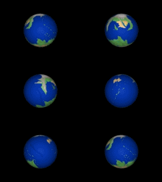
About fifteen years ago, as I was exiting the computer games industry, I had one of my nerd-ier moments and spent some considerable time on constructing a map of Pern: the fictional world created by Anne McCaffrey in her SF series The Dragonriders of Pern and a favourite haunt of mine since my early teens. Initially, my motivation was simply to create a 3D model of a world that you could view from any angle and zoom into (much like Google Earth). I didn’t have plans to use it for anything and was more interested in some of the PC-graphic-card technology then available and what I might achieve with it: this experimental approach to technology had frequently resulted in interesting opportunities. Pern just seemed like an obvious (to me) choice, so I created a simple hand-sketched map based on the drawing published in Dragonsdawn and programmed my simple app’.
Of course, the software was then let down by a scanned pencil sketch, which further distorted when transformed to the 3d model, so I created a new colour-coded map, using copies (note the plural) of The Atlas of Pern (which became so worn that I had to replace them twice). I converted the map to an equirectangular (or la carte parallelogrammatique) projection, as this is the standard used for 3D world mapping. I’ve made this sound simple, but it actually took quite a long time and a large effort to achieve a level of accuracy that I was happy with. Also, some time before then, I had mentioned to Anne the possibility of using The City Who Fought (co-authored with Steve Stirling) as the basis for a computer game (which I still think is a great idea) and had thought that a fully controllable 3D model of Pern might help with furthering my “fan” credentials…
The results were significantly better and, after adding in some of the surface detail, I was then able to create a simplistic “bump map” (using the alpha channel) that allowed the 3D model to display the terrain height properly. Adding a light source (Rukbat) resulted in quite an attractive model (a mountainous planet results in some great “shadow” effects), although the swathes of monotonous surface colour and the height-smoothing technique I’d applied, gave it a very “plastic” look which I wasn’t at all happy with. I replaced the map with one of the Earth and the results were vastly improved, so my focus now switched to the quality of the map of Pern.
The next obvious steps were to blend in Earth satellite imagery of similar terrain (filtering it for a slightly bluer cast), add a cloud layer and create the tools to enable population of the different map magnifications for the zoom: I had intended to ask denizens of the Kitchen Table forum for assistance with the map population. Unfortunately, I was part-way through this when my personal life went through a significant period of major upheaval, so the project was stalled and shelved. I copied the map to a few peeps on the KT and the work-in-progress app’ to an even smaller select number. But, that was the end of that…
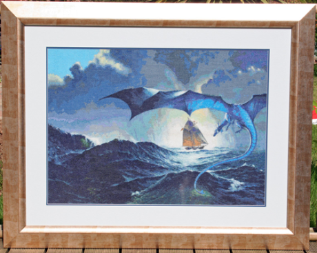
Now, well over a decade later, my wife has decided to create a quilt, or bedspread, featuring a map of Pern (yes, she too is a fan of Anne’s writings), surrounded by all of the Weyr, Hold and Craft badges (read the books if you need an explanation). This may sound overly ambitious, but this is the same girl who created a 160,000 cross-stitch of Les Edward’s cover-art for Dragonsblood (thank you, Les, for the permission), as a birthday present to me a few years ago (it took two years of part-time effort). If you know us, you may have seen her various creations (jewellery, coats, dresses, et cetera) online at some point and, if so, will therefore understand why I have every confidence!

The 160,000 stitch Dragonsblood
Unfortunately, a thorough search on Google hasn’t supplied anything that she can use (steal) as a basis for the project. An equirectangular projection might not be the best presentation style for a quilt, but anything else would cause severe problems with adding text and she would like all of the known “9th Pass” features (once again, read the books if you need an explanation) to have accompanying descriptions. She isn’t unhappy with the prospect of slight horizontal distortion to the north and south as any gross effects would primarily affect the mountainous, or snowy waste, regions and it is, after all, a format that people are generally familiar with.
Also unfortunate is the fact that I have, over the years, mislaid the majority of my original mapping material. However, I did, luckily, discover a 384MB partially-satellite-quality image that I could dumb-down (you have to love Photoshop) to what was required, as well as a few of the original demo’ animations that I created. Even just having the coastline and rivers would have made me happy, so this was a bonus.

A clipping from the original 384MB file

A rough GIF animation (I can't upload the AVI's for some reason) of Pern
The second step was to create a program that could create quilting squares which an embroidery machine would recognise. The software for this turned out to be relatively easy (it only took an evening) to program, as the output isn’t a whoopy-do 3D model, but a simple series of 2D tiles. I split the map into two-hour (30 degree) segments and scaled it to cover the width of a super-king-size bed, so each tile is a 5.59” (142mm) square, making the overall width 67.125” (1705mm). This will only use up half of the available height (as taken up to the pillows), which then allows room for a total of 72 badges: using the same quilting square size to give six rows of twelve badges each. The software automatically appends a ¼” (6mm) border around each tile to make the final construction easier and neater. For any other nerds out there, I’ve used the standard 96dpi as a pixel measure so this equates to a map size of 6444 x 3222 and a tile size of 537 x 537, with a border of 24 (585 x 585 overall).

An example of one of the 72 map tiles
The single and best reason for doing this as a program is that we can make constant changes to the map and simply double-click the app’ whenever we want an updated set of quilt squares. 🙂
So, embroidery machine now purchased (Mother’s Day, Birthday and maybe even Xmas, all covered in one foul swoop) and software written, it’s on to the mapping exercise…
My wife doesn’t require Google-Pern quality, as she wants it to have a slightly children’s-mediaeval-map flavour, hence the dumb-down, but she doesn’t want a simplistic black-on-sepia map either: this wouldn’t work, as some of the badges rely upon colour for differentiation. So, I’ve colour-coded the terrain for now, added the features (temporarily as red dots), added the text (temporarily in white) and run it through the software, so that she can run various tests on the new machine.
The plan is to experiment with various levels of terrain detail and style, whilst simultaneously calling on the experts of “A Meeting Of Minds” and “The Pern Museum & Archives” to help with the map accuracy. I may not agree with everything they tell me, as there are more than half a dozen places referenced in the books that simply don’t have sufficient information to accurately locate them on a map, but there are particular peeps whose opinion I would value highly. Beyond that, it’s very subjective.
I also need to draw icons to replace the location-placeholder red-dots. I intend to create a small dragon for the Weyrs, a gatehouse for the major Holds, a cavern entrance for the minor Holds and a workhouse (something like a mini-Cornish-tin-mine) for those Crafthalls that are geographically separated from their Holds. I’ll also need to create heraldic “supporters” for the different badge type templates and the map will need a compass, dolphins, ships, a large gold dragon (I’ll ask my wife to speak very nicely with Les Edwards about reusing one of his, as they are awesome) and, of course, the flag of Pern. Finally, I’ll use a mix of The Dragonlovers Guide to Pern (2nd Edition) and some great fan graphics on A Meeting Of Minds as inspiration for the shield and badge templates.
Busy, busy, busy! Although we are hoping that this will remain a “this year” project.
Watch this space…
20/03/12
Categories: Uncategorized . Tags: Anne McCaffrey, Pern . Author: lrmason . Comments: 1 Comment


